Trail Walking Les Belleville - Montagne de Cherferie - Photo
 flip38
flip38

User

© OpenStreetMap contributors
Length
Length
17.4 km
Max alt
Max alt
2285 m
Uphill gradient
Uphill gradient
829 m
Km-Effort
Km-Effort  
28 km
Min alt
Min alt
1496 m
Downhill gradient
Downhill gradient
832 m
Boucle
Boucle
Yes
Creation date :
2021-07-02 06:58:03.664
Updated on :
2021-10-02 16:02:52.497

(0 Reviews)

Walking
Walking
5h42
Difficulty : Medium

Scan this QR Code to open this trail in the SityTrail application

FREE GPS app for hiking

Logo SityTrail SityTrail

IGN / Geographical institutes

Download SityTrail from the App Store Download SityTrail from Google Play

Logo SityTrail SityTrail World

The world is yours!

Download SityTrail from the App Store Download SityTrail from Google Play Download SityTrail on Huawei AppGallery

About

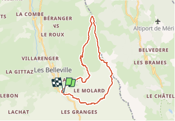
Trail Walking of 17.4 km to be discovered at Auvergne-Rhône-Alpes, Savoy, Les Belleville. This trail is proposed by flip38.

Description

Belle boucle au dessus de la vallée des Bellevilles.
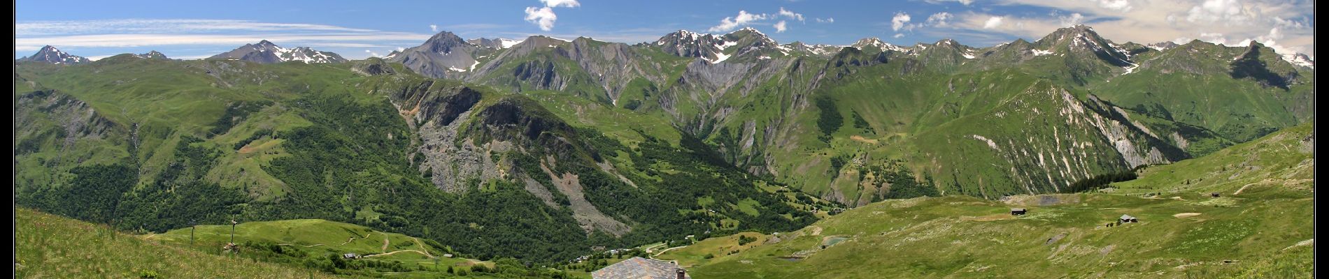
Sommet panoramique, même si une remontée mécanique occupe le sommet, mais cela est très peu gênant.
Sentiers biens tracés, l'arrivée au sommet est soutenue.

D'autres informations sur mon site : http://surlessommets.blog.free.fr/

Elevation profile

Photos

Positioning

Country:
France
Region :
Auvergne-Rhône-Alpes
Department/Province :
Savoy
Municipality :
Les Belleville
Location:
Saint-Martin-de-Belleville
Start:(UTM)
305133 ; 5027227 (32T) N.

Trails nearby

Trail Walking Les Belleville - Le sentier des Choumes ( N °9) - Photo
Walking
GUIDE
mumu.larandonneuse

Walking

Easy
Les Belleville, Auvergne-Rhône-Alpes, Savoy, France
6.7 km | 8.8 km-effort
1h 36min
No
Trail Walking Les Belleville - Le sentier Giraud - N° 8 - Photo
Walking
GUIDE
mumu.larandonneuse

Walking

Easy
Les Belleville, Auvergne-Rhône-Alpes, Savoy, France
5 km | 6.5 km-effort
1h 9min
No
Trail Walking Les Belleville - St Martin Belleville-gittamelon - Photo
Walking
GUIDE
HERRY

Walking

Easy
Les Belleville, Auvergne-Rhône-Alpes, Savoy, France
8.2 km | 13.3 km-effort
3h 30min
Yes
Trail Other activity Les Allues - meribel ski 2 - Photo
Other activity
Cricounet84

Other activity

Medium
(1)
Les Allues, Auvergne-Rhône-Alpes, Savoy, France
67 km | 163 km-effort
5h 12min
Yes
Trail Other activity Les Belleville - Menuires Lac du Loup - Photo
Other activity
jpksenicz

Other activity

Very easy
Les Belleville, Auvergne-Rhône-Alpes, Savoy, France
14.5 km | 21 km-effort
1h 26min
No
Trail Walking Les Belleville - crêtes de Méribel depuis Tougnete - Photo
Walking
bymarc26

Walking

Medium
Les Belleville, Auvergne-Rhône-Alpes, Savoy, France
14.7 km | 23 km-effort
4h 8min
No
Trail Walking Les Belleville - Beranger La croix de Jean Les refuges Le col de la lune - Photo
Walking
zazie

Walking

Difficult
Les Belleville, Auvergne-Rhône-Alpes, Savoy, France
14.5 km | 25 km-effort
4h 12min
Yes
Trail Walking Les Belleville - pointe de la levriere - Photo
Walking
whisper73

Walking

Easy
(1)
Les Belleville, Auvergne-Rhône-Alpes, Savoy, France
5.6 km | 15.8 km-effort
2h 26min
No
Trail Walking Les Allues - Meribel-les Allues par les cols de Saint-Jean et de la Lune - Photo
Walking
Leemans

Walking

Medium
Les Allues, Auvergne-Rhône-Alpes, Savoy, France
16 km | 28 km-effort
4h 50min
No


Close
My subscriptions